Project Description:
Together with our partner 3DS-Scan, which offers software programs for surveying & GIS data, CAD plans and Revit models in highest quality, we digitally surveyed a dam reservoir with a DJI Zenmuse L1.
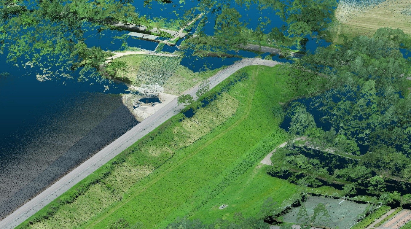
What is a dam reservoir:
A dam Reservoir or fill dam is the shut-off structure of a dam or impoundment consisting essentially of an earth or rock fill. As a rule, a dam blocks off a valley cross-section.
Why was measurement carried out / problem definition:
The purpose of the flight was to record the flood line in the reservoir of the Kronenburger See after the flood in NRW / Rhineland-Palatinate at the end of July.
In addition, the vegetation penetration of the Zenmuse L1 was to be tested to see whether a more accurate terrain model can be generated with it.
How drones can help with a survey:
Drones are not a replacement for proven traditional methods, but the right drones and payloads can complement existing efforts and expand capabilities.
Drones can provide a large amount of information at a faster pace.
Key uses and benefits of survey drones include:
- HIGH ACCESSIBILITY: Hard-to-reach areas can be flown safely. Surveyors on the ground do not have to put themselves in danger, construction work, machinery and equipment can work without interruption during a drone survey.
- PRECISE SURVEY: A GPS ground station combined with the latest drone technology and high-resolution cameras enables precise drone surveying of large areas.
- REPEATABILITY: The ease of repeatability of drone surveying allows for target/actual comparisons as well as accurate documentation of changes over time.
Surveying drone in use: dam reservoir project:
Matrice 300 RTK
This drone has everything you need for effective surveying. From a safe distance, you can survey and get a quick overview of the area. The 55-minute flight time means you can gather the information you need in just a few flights.
DJI Zenmuse L1
The Zenmuse L1 includes a Livox lidar module, a high-precision IMU, and a camera with a 1-inch CMOS on a gimbal stabilized on three axes. When used in conjunction with the Matrice 300 RTK and DJI Terra, the L1 forms a complete solution that provides real-time 3D data throughout the day. It captures the details of complex structures and delivers highly accurate reconstructed models.
Data recording
- Flight at 100 m height with DJI Matrice 300 RTK with DJI Zenmuse L1
- RTK correction with Sapos NRW
- Automatic flight grid with calibration (start and end)
- Scanning Zenmuse L1 Linear RGB highest frequency with approx. 60 % overlap between flight paths
- Warm-up time L1 approx. 5 minutes
- Flight time total approx. 30 minutes
- Area approx. 40 hectares (lake with dam)
Evaluation
- DJI Terra (V3.1.2) with optimization of accuracy
- Target KBS (coordinate system) ETRS 89 / UTM 32N (epsg 25832)
- Point cloud format .las
- Analysis and visualization with CloudCompare (v 2.11)
- Conversion of ellipsoidal heights (WGS 84 resp. ETRS 89) into normal heights resp. use heights (DHHN2016)
- Filter scanangle from 35° to 30
- Comparison with terrain model from state survey (DTM 1 meter grid NRW)
- DGM (Digital Terrain Model) generation with Cloth Simulation Filter (CSF Filter).
Resume:
Advantages:
- Fast acquisition with low effort and good georeferencing (+- 10 cm) without further processing
- Parallel acquisition of image data for e.g. additional photogrammetric analysis
- RGB point cloud (RGB interpolated from color images)
- High point density
- Water surfaces are captured
- Lowest cost Lidar sensor
Disadvantages
- Low penetration of very dense vegetation (summer)
- Detection of only three lidar repeats
- Relative accuracy is about 10 cm, quite high point noise (due to lower sampling frequency probably slightly better results regarding point noise but also lower point density)
Click here for the full article.